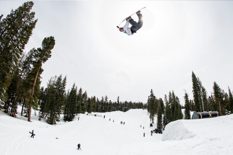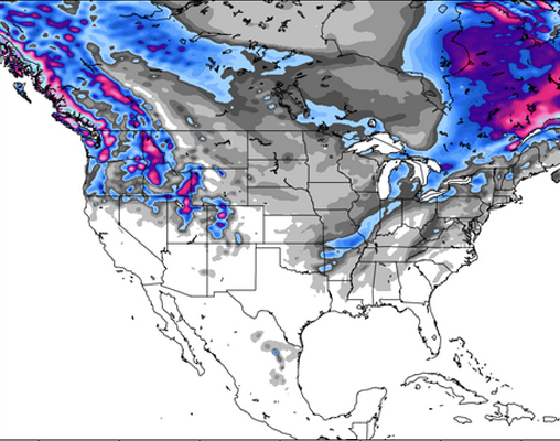
Dreams of a powder-filled new year are certainly ringing true across the West, where Utah, Colorado, the PNW and the Northern Rockies are predicted to receive hefty doses of snowfall throughout the rest of this week and through the weekend. Topping the charts, however, are the PNW and Northern Rockies, where the forecast calls for heavy accumulations every day through sunday. Oregon is expecting over 60″ over the next five days, an impressive tally rivaled only by the hefty snowfall hitting Wyoming, Montana, and Idaho, where the storms will be dousing the mountains on repeat clean into next week. The top powder day of the week, according to the big brains of OpenSnow.com, will be in Oregon on Thursday, as Timberline and Mount Hood Meadows boast 18 and 17 inches of fresh snow, respectively.
The ‘polar vortex’ continues to hit the east hard, with the Midwest expected to experience the lowest temps, though North Easterners should definitely not shy away from layering up. Due to lake effect, Northern New York and Northern Michigan should see some fresh snow, though totals will be slight as compared to what’s going down across the West.

The Pacific Northwest:
The PNW is finally going to see some of the snowfall that has been bypassing it lately, as areas across the state are predicted to receive new snow throughout the rest of this week and on through the weekend. Over the next five days, they are predicted to receive some of the top snowfall in the country, with totals reaching to 35″ at Timberline, OR, and a whopping 66″ at Mt. Baker. Thursday is shaping up to be the best powder day of the week across the West, with Oregon topping the charts with the highest totals. While Mt. Baker is going powder crazy, Stevens Pass and Crystal Mountain in WA are also topping the leader board in terms of accumulation, predicted to see 48 and 51 inches, respectively, by Friday. While things will quiet down slightly across Washington through the weekend, Crystal Mountain, Mt. Baker, Stevens Pass and White Pass are still seeing double digit accumulation in the forecast.
The Northern Rockies:
Montana is sitting pretty this week, with snow predicted to keep on keeping on for most of the next 10 days. To kick things off, a nice base of 1-6 inches is predicted to coat the state on Wednesday, with another 3-6 added to the pile on Thursday— unless you’re lucky and in Montana Snowbowl, where totals may reach 8 inches. Up to another 4 inches are expected to fall on Friday—up to 8 inches at Lost Trail Canyon, with an additional 20 over the weekend. The same trend goes for the rest of the state, where hefty accumulations will be stacking up over the weekend and in next week.
Moving on over to Wyoming, the powder keeps on coming, with Jackson Hole seeing 1-6 inches on Wednesday, 2-7 more on Thursday, 4-12 inches on Saturday, and 3-10 capping out the window on Sunday. For its part, Grand Targhee is expected to see 7 inches on Wednesday, 8 inches Thursday, 7 inches on Friday, 4-12 on Saturday, and 3-10 on Sunday. Last but certainly not least, Teton Pass is predicted to receive up to 6 inches on Wednesday, with another 2-7 on Thursday, 1-10 on Friday, 4-12 on Saturday, and 3-10 on Sunday.
Ahh the powder is calling, and we’re tempted to call in an absurd number of sick days…
The Northeast:
Looks like the NE has been sucked into the ‘polar vortex’ currently taking over 2/3 of the country. Thankfully, this region won’t be hitting historic lows the way the Midwest is, but we’re still seeing some serious cold. Highs will be just around 10 on Wednesday, warmer in the south than the north. The only promise for snow comes for northern resorts at high elevations, with snow showers dropping just about 1-3″ starting Tuesday night and on through Wednesday. Resorts across Vermont, New Hampshire, and Maine are looking very dry, with Bretton Woods and Loon being the only resorts possibly receiving an additional inch on Thursday. Long range forecasts are looking a little too warm and rainy for our tastes, as January thaws out just a bit.
Check out the New England Daily Snow for more details
Colorado:
For the coming week, 3 waves of snowfall are predicted to make their way through Colorado. Round one should drop just about 2-4 inches in Central and Northern Colorado, Tuesday night through Wednesday morning. The second dose is predicted to come in on Thursday night and keep on through Friday night, bringing with it anywhere from 1-4 inches for areas across the state. Things will mellow out again on Saturday morning, though the 3rd wave of snowfall is expected to move in that very night and continue on through Monday morning. This third storm looks the most promising in terms of accumulation, with 4-8 inches expected to fall. According to Colorado Daily Snow’s Meterologist Joel Gratz, Sunday and Monday morning are the golden days for some powder turns.
Need more? Check out Joel Gratz’ daily forecasts
Utah:
Things are looking up for Utah, where things have been a bit dry for the past few weeks. Meteorologist Evan Thayer is predicting somewhere between 12 & 20 inches of snow to fall within the coming week— up to 16″ predicted by Friday— as a series of weather systems make their way across the state. At least six separate waves of snow are making their way towards Utah, the first coming in on Tuesday and lasting through Wednesday. This wave is expected to drop off about 1-3 inches of fresh in the meantime, though the system is weak and may only affect the Northern Utah mountains. The second system looks like it will move in on either Thursday or Friday, and is expected to bring in 5-10 inches, making for a total of 6-12″ before Friday; hello, powderful weekend. The third and final system comes in Saturday evening, and though the forecasts aren’t inspiring solid confidence, another 5-10 inches is possible. Looks like it’s going to be a solid week of snowfall, so grab your powder boards and go milk it!
For more info on the forecast for Utah, click here
The Sierras:
It has been a bit of a rough go over in the Tahoe region, and while it looks as though Wednesday night will bring a light coating — just about an inch— and Saturday night will be graced with another 1-3 inches across the basin, weather models are unfortunately predicting a pretty dry week after that system wraps up on Sunday.

For more weather-wisdom, Bryan Allegretto is your guy
The Midwest:
In case you missed it, the Midwest has been dealing with some serious frostbite the past few days, with the mercury dipping down below -50. Thankfully, the next few days should slowly warm up, with temps breaking 0 degrees on Wednesday. As far as snow is concerned, lake effect should bring light to moderate accumulations to parts of Northern and Central Michigan through Wednesday. The further east you go, the better chance for snowfall. Northern Minnesota may see a few snow showers move through Wednesday night and Thursday, but forecasts are calling for a drier week overall.

For more info on the Midwest, get the lowdown from Meteorologist Andrew Murray