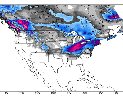
Heading into the second week of January, it looks like the panhandle of Idaho, western Montana, Wyoming, and northern Colorado are sitting pretty on some powder. Northern Washington, though a bit dry in the next few days, could be hit with upwards of 6 inches a day starting on Wednesday, 1/8. More snow has been falling in the Northeast, with totals up towards 18″ in some very lucky areas. Moving into the weekend, however, it is looking a bit more bitter than snowy, with temps dropping to around -10 degrees, though even that has got nothing on the Midwest, where locals are expecting a record low to hit on Monday, with the mercury dipping down to around -50. Overall, it looks like it’s going to be a powder-ful weekend across the country, so grab your boots (and about 3 jackets if you’re in the Midwest) and take full advantage!
Check out forecasts for the days ahead, courtesy of our friends at Opensnow.com…

The Pacific Northwest:
The forecast is looking mighty dry up towards Oregon, with resorts across the state looking at a solid few days sans snowfall. The only exceptions are Spout Springs and Ski Anthony Lakes, which are predicted to see just about 6 and 3 inches, respectively, and not until Tuesday. Stevens Pass is looking at 1 inch Friday night, with nothing more until Monday night, though again they are expecting just about 1″. WA in general is looking pretty mellow, following in the same trend as Stevens Pass and getting about an inch Friday night with little else falling until Monday night or Tuesday. However, looking ahead to Wednesday the 8th, Crystal Mountain, Mt. Baker, Mt. Spokane, and Stevens Pass are all seeing the possibility of up to 6″ Thursday, with an additional 1-6″ predicted every day through Sunday. Mt. Baker may even see over 12 inches on the 9th. So while the next few days are looking a bit dry, it seems as though the snow gods are simply biding their time before breaking out the big guns later on next week.
The Northern Rockies:
Checking in with Montana, it looks like Showdown Mountain and Teton Pass Resort could see anywhere from 3-5 inches Friday night, plus an additional 2-4 on Saturday. On through Saturday night and Sunday, an additional 5 inches are expected to pile up, before the storm wraps up on Monday. Snowbowl is looking at up to 3 inches Friday, with an additional 3 coming Friday night. Saturday is expected to mellow out, with just 2 inches falling before Sunday dries out completely. Tuesday is promising another round for most of the state, though accumulations are predicted to be capped at about 4 inches. Moving over to Wyoming, this weekend is looking pretty fine, as Grand Targhee, Snow King, and Teton Pass all expect upwards of 3 inches Friday, with an additional 2-5 falling overnight. Saturday brings another round of 1-3 inches across the state, though many areas mellow out on Sunday. Similar to MT, WY looks pretty dry for Monday, with a storm ramping up for another round come Tuesday night.
The Northeast:
After another round of snowfall fell over the NE last night, with the best accumulations building up in the Berkshires, in MA, where Bradford boasts 18″ of fresh, while Nashoba Valley and Blue Hills earned about 12. Looking forward, temps across the region will continue to drop and the wind is moving in for the weekend. It looks as though the cold may be pretty brutal, as meteorologist Brian Clark notes, “I really can’t remember a major snowstorm with temperatures this cold in my lifetime.” But hey, at least if it’s going to be that cold, there will be some great snow to make that frostbite worth your while. The thermometer is going to be dipping below -10 at most every resort, so bundle up before you get out to enjoy that fresh snow!
Need more Northeast? Check out The Daily Snow via Brian Clark.
Colorado:
Kicking off Friday night, heavy snow is expected to hit Colorado through Saturday afternoon. Saturday is looking like a prime powder day along and to the north of I-70, with Steamboat, Winter Park, Breckenridge, and Copper favored by snow blowing in with a NW wind flow; Colorado Daily Snow meteorologist Joel Gratz notes that the set up is promisingly similar to the system that dropped around 10 inches a few days back. When all is said and done, the aforementioned resorts could be doused with up to 12 inches of fresh snow, while mountains in the central and souther regions of the state are looking at a more modest 2-4 or 3-6 inches. While the snow appears to wrap up Saturday night, the temps will remain pretty bitter throughout Sunday. Monday and Tuesday are expected to dry out a bit, with another chance for snowfall coming on Wednesday. Looking ahead, the weeks to come are looking mighty snowy, and we don’t hate that!
Find out more about Colorado, via the Colorado Daily Snow.
Utah:
This weekend will bring a small dose of snow to Utah, as a weak storm moves in Friday night to drop off around 1-4 inches in Northern Utah. A weak system may also blow through early next week, though not much accumulation is expected. Park City and Snowbird are looking at about 1-3 inches Friday night, and another inch Saturday, while Canyons and Snowbasin are expected to receive just about 1″ Friday, and 1″ Saturday.
For more forecast updates on Utah, click here.
The Sierras:
Up around Tahoe, there are three promising systems predicted to hit throughout next week. Tuesday, Wednesday, and Thursday all come with the possibility of snow, though it looks like just a dusting. Another system moving in through the weekend, however, is expected to drop over 6 inches. Most of the long-range ensemble runs show the ridge rebuilding week 2 bringing a return of dry conditions going towards mid-month.

For more weather, check out Bryan Allegretto’s Tahoe Daily Snow
The Midwest:
Heads up Midwest, it’s about to get chilly. As a cold front makes its way down into the Midwest from the Great White North, the region is expected to see snowfall in northern Minnesota and Michigan. The heaviest portion of the storm is expected to hit Friday night, tapering off before sunrise Saturday morning. This area is looking to receive around 4-8″, with lake effect on the Keweenaw and near Newberry upping the totals into the 6-9″ range. Beginning on Sunday night, temps are expected to sit just below zero, but come Monday, the thermometer will dip into the -50 range… you heard right. -50. We’re going to recommend you throw a few logs on your fire and stay inside as the Midwest experiences this record breaking cold. The temperature is supposed to raise into the negative teens on Tuesday, an improvement, but still pretty painful. This cold front will move out of the region as next week progresses, allowing the temps to warm up a bit.