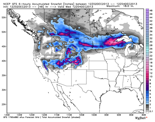
December is upon us, and the Snow Gods are clearly in a giving mood, as snow storms continue to make appearances across the country. Here’s what we’ve got on the docket this week, according to the weather masterminds at Opensnow.com: Colorado and Utah can expect an especially hefty dose of fresh, while Tahoe Basin is sitting pretty with 6-12 inches heading its way. The Midwest is also predicted to gain a solid few inches, capping out at around 10. The temperature drops are no joke, as Utah prepares for the coldest week of winter and the rest of us can look forward to some single digit chills.
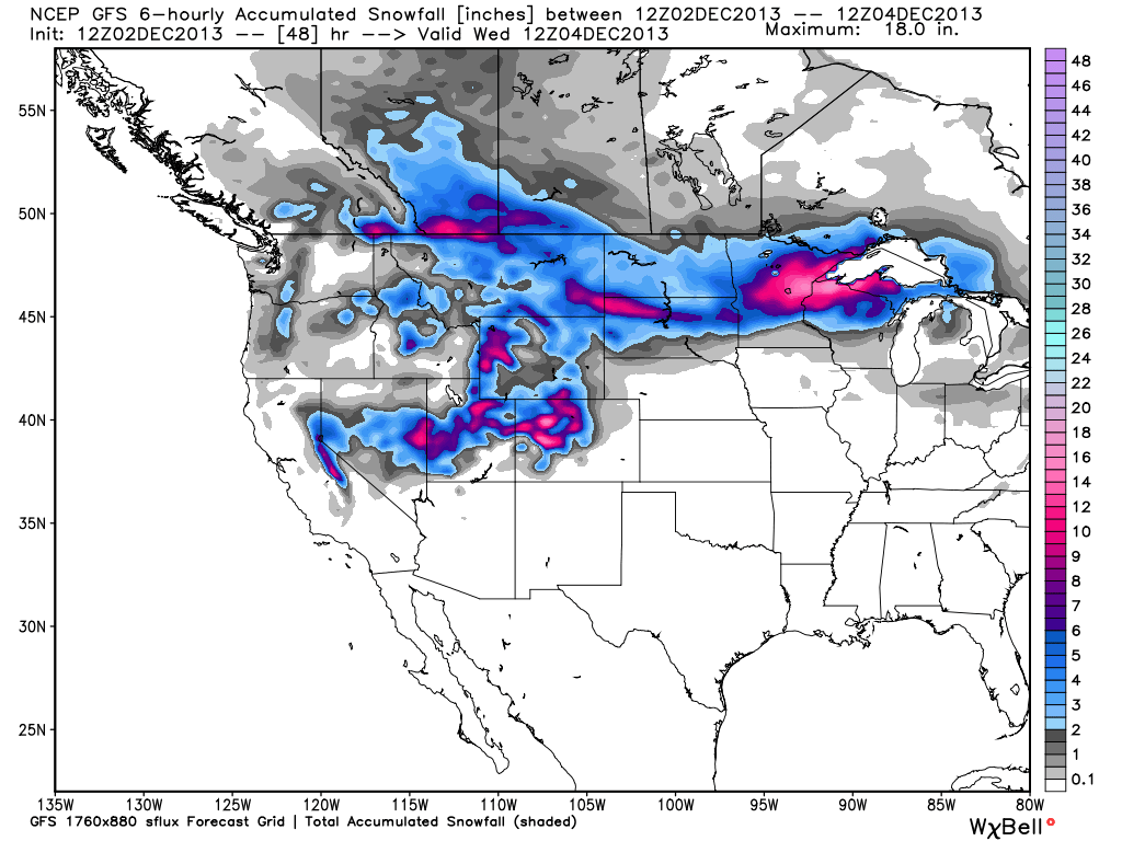
The clouds came in last night and left a dusting, but the real storm is set to drop on Tuesday afternoon, predicted to leave the mountains with anywhere from 10 to over 18 inches of fresh powder by the time it wraps up Wednesday night. While the snow is expected to clear out through Wednesday night, temps will be dropping, with lows below zero and highs peaking at around 15 degrees. All mountains in CO are expected to see new snow, so hopefully you’ve been saving up your sick days in preparation.
Stepping over to Utah, a storm currently making its over to SLC will make its mark by midnight, dropping anywhere from 4-8 inches North of I-80, and anywhere from 6-12 inches South of I-80 by mid-morning on Tuesday. Wednesday brings with it another host of storms, after which the total accumulation should look something like this:
— Wasatch north of I-80 above 6,000 feet: 6-12″
— Wasatch south of I-80 and north of Provo: 8-14″
— Mountains of central/southern Utah: 10-20″
Some light snow may make an appearance Thursday and Friday, though Saturday and Sunday are looking much more promising, with another 4-12 inches expected to fall. The man behind Utah’s Open Snow Daily, Evan Thayer, notes that this is expected to be the coldest week of the winter in Utah, sticking stubbornly below 0 degrees on the mountain tops, so throw on a hat (or three) before making moves to higher ground!
Moving into the Midwest, snow showers picked up this morning, and are set to continue through Wednesday. Areas along the North Coast are looking at around a foot of new snow, while Norther Wisconsin can expect around 8-10 inches. Crossing coasts to Tahoe, storms are set to descend on the area tonight, starting as early as midnight and gifting lake-level zones with 5-9 inches of fresh, while above 7,000 ft. the number jumps up about a foot. Speaking generally, about 6-12 inches of snow are predicted for the Tahoe Basin is expected starting tomorrow, followed by very cold air into the weekend.
There you have it folks! What to expect (or hope for, rather) heading into the first week of December. Snag some serious layers and we’ll see you out there.