Powder fiends, Mt. Baker is calling your name. The PNW is currently getting slammed with new snow, with 41-68 inches projected to stack up at Mt. Baker by Saturday. Montana, Wyoming and Idaho are also looking at a pretty stellar week, with Montana Snowbowl expected to receive up to 34 inches by the time the weekend rolls around. The Midwest is getting a nice little dose of snow throughout the latter half of this week, while the Northeast gets a little loving Wednesday and Thursday as well.
Read on to see what the big brains over at OpenSnow.com have predicted for your zone this week.

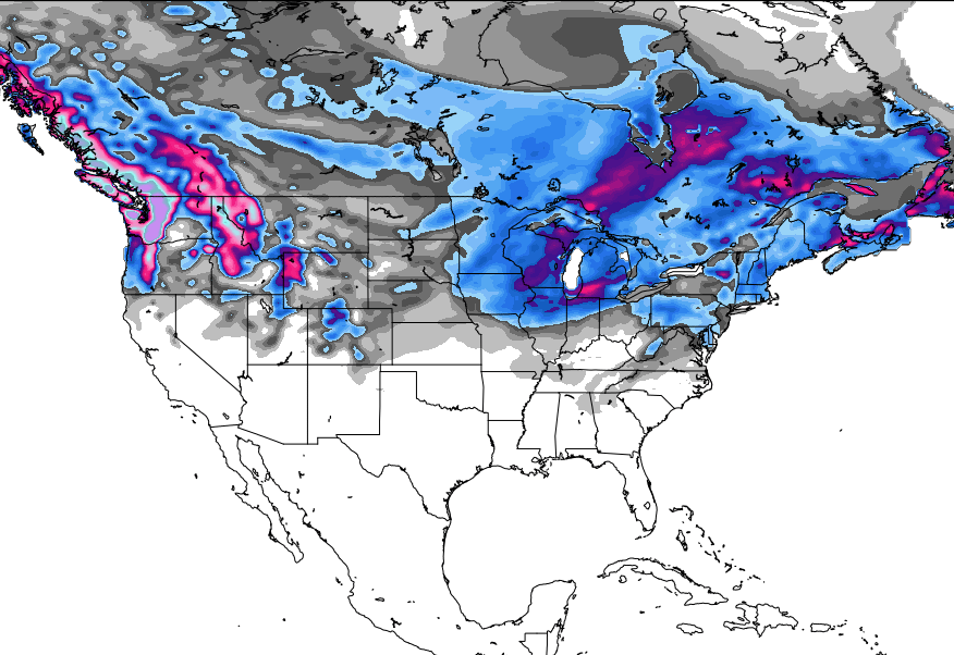
The Pacific Northwest
Washington is looking pretty killer at the moment, with snow falling at a rate of about an inch an hour, which is expected to increase over Wednesday night and into Thursday. By midday Thursday, the forecast calls for 7-14 inches of fresh. Come Friday, the snowfall is expected to slow, though another dose of 1-5 inches will make an appearance. On the whole, this storm, which began at the beginning of this week, will have brought anywhere from 5-10 feet of new snow to WA by the time it wraps. Stevens Pass and Summit at Snoqualmie are both in fantastic shape, with new snow adding up to 20 and 16 inches, respectively, by Thursday. Mt. Baker is the spot to be however, as 41 to 68 inches of new snowfall are projected to fall by Saturday morning.
Over in Oregon, Mt. Hood is looking at up to 15 inches by Friday morning, While Mt. Bachelor and Timberline are predicted to see 13 inches in that same time frame.
The Northern Rockies
Beginning Tuesday and continuing on through Saturday, the snow is dousing Montana this week, as Big Sky is looking at 8 to 21 inches, Bridger Bowl 8 to 21 inches, and Montana Snowbowl 16 to 34 inches of new snow when all is said and done.
Idaho is looking at a week similar to that forecast for MT, with snow beginning Tuesday and wrapping up on Saturday. By this weekend, Lookout Pass is projected to receive 21 to 44 inches of new snow, while Schweitzer could see anywhere from 12 to 29 inches and Silver Mountain can expect 18 to 38 inches.
Moving on to Wyoming, forecasts call for 12 to 26 inches of fresh snow for Grand Targhee by Saturday night, while Jackson Hole is looking at 15 to 34 inches.
The Northeast
The snow continues to fall in New England, with another 2-4 inches making its way to the region Wednesday afternoon and night. This new storm is predicted to focus on resorts in Southern NH, with the eastern slopes of the White Mountains, Western ME, and Central MA also getting some more love. While the end of the week does appear to warm up, this rise in temp will be short lived, as the cold is expected to return by the tail-end of the weekend.

Need more Northeast? Brian Clark has you covered.
Colorado
Starting Wednesday, the snow is taking over CO once again. The snow is expected to come in around 2pm Wednesday afternoon, with 4-6 inches of fresh predicted to have gathered by Thursday morning, though mountains along I-70 may see up to 8 inches by the time the lifts start running. Colorado Daily Snow meteorologist Joel Gratz predicts that the storm will ease Thursday afternoon, before amping up again on Thursday night. The same trend is expected for Friday, with lighter snow during the day before a heftier dose comes in at night. Colorado should see light accumulations Wednesday through Sunday,with smaller amounts of snow falling day over day, resulting in solid overall accumulation. The region is expected to start drying out on Sunday, with no new snow expected for Monday, Tuesday or Wednesday.
Utah
A strong storm system is currently moving across Utah, dropping anywhere from 4 to 8 inches on the region by Wednesday night. As Evan Thayer notes, “This is a last chair today, first chair tomorrow type of storm.” Clouds and mild snow showers are forecast through Saturday, before the weather clears and the temps rise Sunday through Wednesday of next week.
The Sierras
Those in the Tahoe area got a nice little dusting early on this week, as part of a weak cold front that has been moving across the region. Models are consistently predicted that a system should be hitting The Sierras late next Wednesday. For now, the area is expected to remain steady and dry until the forecasted storm makes moves next week.
The Midwest
Kicking off on Thursday, the Midwest is looking at a solid round of new snow. As Andrew Murray explains, the snow is expected to begin falling Thursday morning in Southern Minnesota, moving north and east as the day progresses, most areas receiving the heaviest snowfall Thursday afternoon. Due to the way the storm is moving, there will be a very clear line of heavier snowfall right along the Southern Minnesota-Wisconsin border, with areas on one side seeing 4-6 inches of snow, while the other side receives anywhere from 8-12 inches. Looking further north, the Northland, North and South Shore, and western portions of the UP are slated to get 10-15 inches by Friday morning.

Alaska
Heading way up north to AK, mild to low temperatures are in the forecast for Eaglecrest, and as a system passes through Juneau Thursday and Friday, an inch or more of snow is expected to fall. A gap in the storm will last for about two days, before more precipitation makes its way to the area. Ovearll, things are shaping up to be pretty mellow.
Powder days are the best days, so be smart and stay safe, friends!