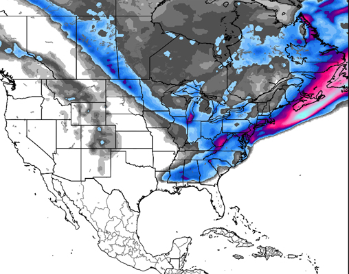
The Midwest is the place to be this week, as the biggest storm in years descends upon the region, leaving the rest of the country to sit quiet and dry. The sun is shining in the Sierras and on across the west, denying new snow to the entire Western half of the US, with the exception of Alyeska, which is making us jealous per usual and expecting new snow every day this week.
Thanks to Open Snow and its resident weather geniuses, we’ve gathered forecasts for regions across the country. Read on to find out what’s going down weather-wise in your region this week.

The Pacific Northwest:
No storms on the horizon for Oregon, and things are only slightly more promising over in Washington, where Snoqualmie and Hurricane Ridge could see just about 2 inches each on Wednesday. It looks as if things won’t be picking up until Tuesday of next week, where up to 6 inches are predicted to coat areas across the state. Way up north, Eaglecrest, AK is just as OR and WA, though its Alaskan neighbor, Alyeska, is predicted to enjoy snow through the week: up to 6 inches could fall on Tuesday, another 6 Wednesday, 1-5 Thursday, with another 6 inches coming over Friday night.
The Northern Rockies:
Continuing in the same trend as the rest of the West, Montana, Wyoming & Idaho are looking at a mellow week ahead. Idaho is silent on the snow front until next Tuesday, the 28th, when a storm system is predicted to blow in and start drop anywhere up to 6 inches. Parts of Montana— Big Sky, Bridger Bowl, Showdown Mountain, Whitefish Mountain, amongst others— should see snow on Wednesday, with Showdown receiving anywhere from 2-7 inches of fresh powder. The week quiets back down after this quick interruption. Moving over to Wyoming, Meadowlark Ski Lodge and Snowy Range are the only places predicted to see even a touch of snow this week, and even then, only about an inch or two. No real accumulations are expected until around Wednesday, the 29th of January.
The Northeast:
Another storm is making moves towards the region, bringing with it another round of arctic chill, as highs keep to the teens and lows dip down towards zero. Up in Northern Vermont, around 2-4 inches are expected to fall on Monday, with New Hampshire and Western Maine seeing just around 3 inches. Wednesday is looking promising for new snow as well, with anywhere from 2-6″ falling near the coast, about 1-3 falling further inland towards the White Mountains. Accumulations are expected to be pretty high with this storm system, which is great news for all you Northeastern riders. Cold temps will be hanging around for a while, though the next chance for a snow storm isn’t predicted until the end of the month.

Click here for more on weather in the Northeast
Colorado:
It’s looking like more dry weather is in store for Colorado. A light snow is predicted to fall Wednesday night into Thursday around the foothills and Eastern plains, but beyond that the next 9 days are looking sunny and bare.
For more info, check out The Colorado Daily Snow
Utah:
It’s warm and sunny in Utah, with no real signs of snow. A change in the weather pattern may hit towards the end of January however, hopefully breaking down the ridge that is keeping the cold air out of Utah. The long range forecast calls for a storm on January 28th, with two more systems to follow. At this point, however, those systems are a bit too far off to count on.
The Sierras:
With mild temps with highs topping out at almost 60 degrees, it’s still looking mighty dry in the Tahoe region. Temps may drop into the 40s later in the week, but so far, no snow in the forecast.
Need more? Check in with meteorologist Bryan Allegretto
The Midwest:
Finally, a forecast we can get excited about! While the rest of the country is drying out, the Midwest is about to get hit with what is expected to be the biggest storm to hit the area in 3 years. With the influx of weather, temps are expected to drop into the teens across the region. Unfortunately, while a good amount of snow is expected, it looks as though the brunt of it will be focusing in on the cities of the MW, instead of the resort slopes that actually need it. Tuesday is the primary day for the storm, as it kicks off around 7am and stays strong throughout the day. The heaviest snow for the ski areas is predicted to hit the Maryland/Pennsylvania border, with about 6″ at Liberty, Roundtop, Whitetail, Wisp, Canaan Valley, Timberline & Snowshoe. Seven Springs should see a little over 3 inches as well.
For more on this storm or the Midwest in general, click here