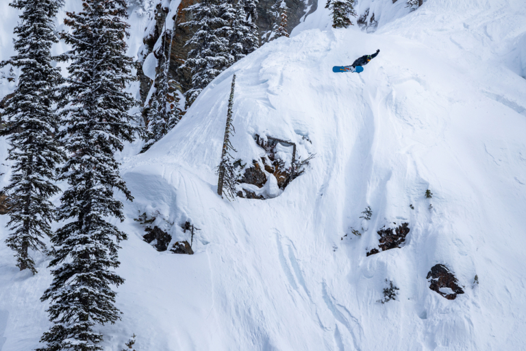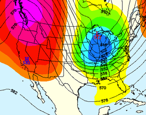
After the PNW and the Western regions of the country basked in the glory of endless face shots and hefty snowfall last week, this week’s forecast is pulling a switch on everyone. According to our favorite meteorologists over at OpenSnow.com, beginning on Tuesday a dry spell will hit the west, while the East enjoys stormier days. The Tahoe region, Oregon, Washington, Wyoming, Montana and Utah are sitting silently, with no new snow predicted to fall in the coming days. For its part, the Northeast seems to be finished thawing out, as a cold front makes its way back to the area this week. The rain is coming in, showers that will (hopefully) be turning into snow near the end of the week.
The Midwest should see light to moderate accumulations in the second half of this week, with certain spots in Michigan and Wisconsin earning around 9″ of fresh snow by Thursday.
Alaska is the big winner this week, as hefty doses of snow are predicted to fall continuously through Saturday, with over 5″ expected to fall every day.

The Pacific Northwest:
Taking a 180-degree turn from last week’s weather, Oregon and Washington are sitting high and dry this week, with zero snowfall on the radar. Looking to the far north, however, Alyeska, AK is looking to rack up 14″ of fresh by Thursday, with 8 inches falling on Wednesday alone. In fact, every day this week is looking killer, with Thursday adding 2 inches of snow to Wednesday’s totals, while Friday boasts up to 7″ and Friday night brings up to 9 more. Saturday keeps it coming, as another 7 inches are predicted to fall. Looks like Ullr is especially stoked on Alaska this week, because they are certainly hoarding the goods.
The Northern Rockies:
After a powder heavy week, things are mellowing out in the Northern Rockies, where little to no new snow is predicted to fall over the next few days. The first signs of snowfall don’t come until next Monday, where a few resorts across Montana and Wyoming may see anywhere from 1-6 inches.
The Northeast:
As the West begins to thaw on Tuesday, the snow will be making moves towards the east coast. Beginning with rain showers, the precipitation should turn to snow by Tuesday night around the Berkshires, Vermont, the White Mountains, and Western Maine, with just 1-3 inches of slushy accumulation. Temps should bump up into the 40s throughout the rest of the week, with the potential for snowfall; meteorologist Brian Clark clarifies, “as many as 4 more storms through the end of the weekend, but the exact timing and strength is tough to make the call on right now.” Looking at specific resort forecasts, Killington may see about an inch Friday, and another Saturday night; Stowe could receive an inch on Thursday night, plus one more on both Friday and Saturday nights; Waterville Valley is looking at about an inch on Friday night, with another 2 added through Saturday, with Cannon Mountain following the same trend. Overall, the rest of this week is looking relatively quiet in terms of snowfall.
Need more Northeast? Check in with Brian Clark and The New England Daily Snow
Colorado:
After an insanely snowy weekend, the snow will continue to fall through Tuesday, but start moving out of the area on Wednesday, leaving Colorado dry for about a week. Predicted powder totals in CO before Wednesday are the highest in the country, with 7″ expected in Steamboat and 5″ predicted for Arapahoe Basin, Keystone, Winter Park, and Breck before the weather mellows out mid-week. Good thing the state received an absurd amount of snow last week— 44 inches of new snow so far in Breckenridge, 22 dropping Sunday & Monday alone— leaving the mountains with very solid bases that should be enough to keep riders happy through the coming dry spell.
Want more info on Colorado? Keep up with Joel Gratz
Utah:
The forecast is calling for sunny skies and warm temps this week, as a ridge comes inland from the Eastern Pacific and hangs over the Great Basin for a few days. Overall, it’s looking to be pretty quiet weather wise for resorts across the state.
For more on what’s going on in Utah, check out The Utah Daily Snow
The Sierras:
Still no luck up in this region, as meteorologist Bryan Allegretto states simply, “High pressure will build along the entire West Coast, keeping storms away from the Western U.S. over the next 2 weeks.” Though the resorts have been killing it as far as making snow is concerned, unfortunately for the Tahoe region this season’s lack of natural snowfall will continue on for the foreseeable future.
The Midwest:
A series of systems continue to move through the Midwest, dropping out of SE Canada and bringing light to moderate accumulations to the Midwest. Tuesday is predicted to bring 1-2 inches to areas in Minnesota, with up to 4 inches falling over the border in Wisconsin. Another system is expected to hit the region on Thursday, but the forecasts are far from solid. As of now, the storm is looking as if it will hit the northern regions of MN & Northern WI. In Blackjack, MI and at Whitecap Mountain, WI, totals could reach up to 9 inches by Thursday, topping the leader board in terms of accumulation for the area.

Check out The Midwest Daily Snow for more info